
 English
Parku Arkeologjik Bylis
Bylis Archaeological Park
Bylis, ngulimi i lashtë ilir që të magjeps me peizazhet e tij
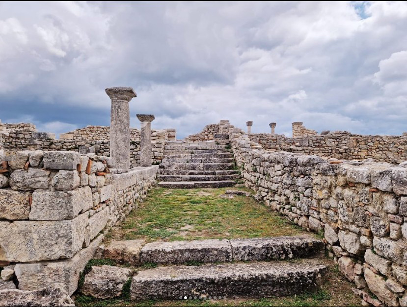
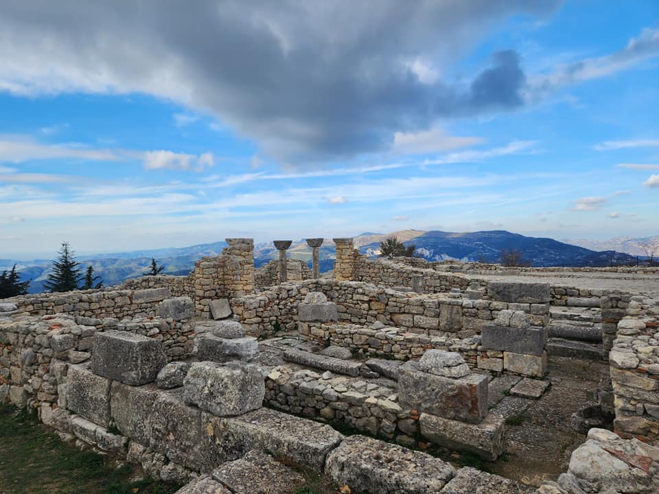
Bylisi është një nga qendrat më të rëndësishme arkeologjike të Shqipërisë dhe i shumëvizituar nga turistët, për peizazhin e pazakontë që e rrethon dhe monumentet që gjenden aty.
Ky park përfaqëson rrënojat e një qytetërimi të vjetër ilir, të quajtur ballaite. Bylis, është i vendosur në pllajën e një kodre pranë fshatit Hekal, në zonën e Mallakastrës, nga ku mund të vëresh një pjesë të mirë të territorit të Shqipërisë, brigjet e Adriatikut, Fushën e Myzeqesë dhe malin e Tomorrit.
Në qytetin antik të Bylisit ruhen rrënojat e teatrit me kapacitet prej 7500 spektatorësh, i cili shërbente jo vetëm për shfaqje të ndryshme teatrale dhe muzikore për banorët e qytetit dhe zonave përqark tij po edhe si vend mbledhjesh ku merreshin vendime të rëndësishme për fatet e bashkësisë byline.
Krahas teatrit, qyteti kishte stadiumin e vet, dy shëtitore, njëra prej të cilave dykatëshe, depozitën e ujit, prytaneonin, gjimnazin, altarë, banesa, rrugë si dhe punishtet e veta të poçarisë, ndërtimit, skulpturës, metalpunuesit si dhe punishten e prerjes së monedhave të veta.
Bylis, the ancient Illyrian settlement that fascinates you with its landscapes
Bylisi is one of the most important archaeological centers of Albania and is often visited by tourists, for the unusual landscape that surrounds it and the monuments found there.
This park represents the ruins of an old Illyrian civilization, called Ballaite. Bylis is located on the plateau of a hill near the village of Hekal, in the area of Mallakastra, from where you can see a good part of the territory of Albania, the shores of the Adriatic, the Field of Myzeqe and the mountain of Tomorri.
In the ancient city of Bylis, the ruins of the theater with a capacity of 7,500 spectators are preserved, which served not only for various theatrical and musical performances for the residents of the city and the surrounding areas, but also as a meeting place where important decisions were made about the fate of the Bylis community.
In addition to the theater, the city had its own stadium, two promenades, one of which was two-story, the water reservoir, the prytaneon, the gymnasium, altars, houses, roads, as well as its own workshops of pottery, construction, sculpture, metalworking, and the workshop of cutting own currencies.
Butrinti, magjia e arkeologjisë dhe mikrokozmosi i Mesdheut
Parku Kombëtar i Butrintit është një nga zonat më të rëndësishme arkeologjike të trashëgimisë kulturore, e turistike të vendit tonë, dhe të rajonit të Mesdheut. Ai ndodhet në jug të Shqipërisë dhe kufizohet në veri me fshatin Berdenesh – Kallmit –Qenuri, në zonën e Vurgut; në lindje me fshatrat Qenuri-Xarrë, duke kaluar nëpër kurrizin e malit të Milesë; në jug me fshatrat Xarrë – Shëndëlli – Vrinë, deri në kepin Stillo; ndërsa në perëndim përmes rrugës nga Berdeneshi përfshi edhe ishujt e Ksamilit shkon deri në kufirin shtetëror me Greqinë.
Në zemër të parkut ndodhet qyteti antik i Butrintit, ku ndërthuren bashkë historia dhe natyra, arsye që e bën Butrintin të jetë një ndër sitet arkeologjike më të vizituara në çdo stinë të vitit nga studiues, turistë të huaj, e vizitorë vendas.
Butrinti është përshkruar si një mikrobotë e historisë së Shqipërisë. Nga vendosja e tij strategjike, Butrinti zë fill në historinë e Mesdheut, që nga lufta e parë e Peloponezit në shekullin e 5-të para Krishtit. Monumentet e tij të ndërtuara gjatë periudhave të ndryshme historike pasqyrojnë këtë histori të gjatë dhe komplekse. Butrinti, Buthrotum-i antik gjendet pranë qytetit jugor të Sarandës dhe shtrihet rreth 3 km nga ngushtica e Korfuzit, i vendosur në një kodër të vogël, rrethuar nga ujërat e liqenit të Butrintit, që lidhen me detin Jon nga kanali i Vivarit.
Sot, rrënojat e shumta arkeologjike të Butrintit dëshmojnë për të shkuarën e tij të pasur. Një çekan guri dhe një bosht, që i përkasin gjysmës së dytë të mijëvjeçarit të dytë p.e.s., janë objektet më të vjetra të gërmuara në zonën arkeologjike.
Butrinti ka qenë pjesë e të dhënave të shkruara që nga shekulli VI para Krishtit, kur historiani i lashtë grek Hekateus e përmendi për herë të parë qytetin në veprën e tij, duke shkruar se Butrinti ishte projektuar sipas Trojës. Sipas Hekateut, emri origjinal i Butrintit, Buthrotos, i referohet demit të flijuar nga princi trojan Enea në rrugën e tij për në Dodona. Në periudhën e hershme të historisë së tij, Butrinti ishte zonë e fiseve kaone, që më vonë do të përfshiheshin në mbretërinë e Epirit.
Gërmimi i parë i thelluar i Butrintit dhe zonës përreth u drejtua nga arkeologu italian Luigi Ugolini midis viteve 1926 dhe 1936. Duke u fokusuar në Butrint dhe në vendbanimin e afërt grek të Finiqit, Ugolini zbuloi një thesar të vërtetë; një batizier, një teatër, një bazilikë, banja publike, një gjimnaz, porta, mure kështjelle, një tempull kushtuar Minervës, si dhe një numër të konsiderueshëm shtëpish, objektesh që dëshmojnë për historinë e saj pjellore.
Rrënjët greke dhe romake të Butrintit janë të dukshme në objektet e jashtëzakonshme të gjetura rreth amfiteatrit: një statujë e Apollonit, një tjetër e perëndeshës së Butrintit, një portret i Agripës, kokat e Zeusit dhe Livias, midis shumë epigrafeve latine dhe greke.
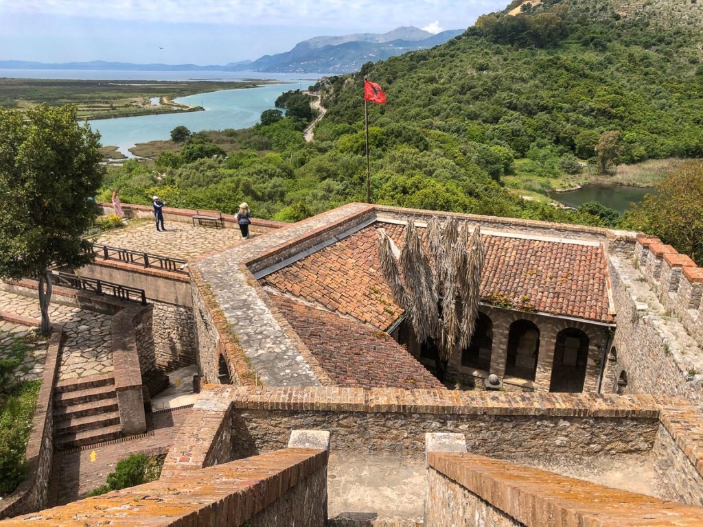
Disa kulla të ndërtuara gjatë periudhës kur venecianët kontrollonin hyrjen në këtë zonë, qëndrojnë ende në këmbë. Aty pranë, vizitorët mund të eksplorojnë edhe kalanë trekëndore të Vivarit, e ndërtuar nga Ali Pashë Tepelena, sundimtari shqiptar, në fillimin e viteve 1800.
Në vitin 1992 Butrinti u pranua si vendbanimi i parë arkeologjik i Shqipërisë në listën e Trashëgimisë Botërore të UNESCO-s. Në vitin 2000, Butrinti u shpall Park Kombëtar në mbrojtje të shtetit dhe UNESCO zyrtarisht zgjeroi sipërfaqen e tij nga 20 ha, që kishte qenë më parë në 29 km². Emërtimi si Park Kombëtar u bë me qëllim mbrojtjen dhe konservimin e monumenteve historike dhe trashëgiminë e pasur mjedisore.
Për më shumë informacion klikoni https://www.butrint.al/eksploro-butrintin
The Butrint National Park is one of the most important archaeological areas of cultural and tourist heritage in our country and the Mediterranean region. It is located in southern Albania and is bordered to the north by the villages of Berdenesh – Kallmit –Qenuri in the Vurg area; to the east by the villages Qenuri-Xarrë, passing through the ridge of Mount Milesë; to the south by the villages Xarrë – Shëndëlli – Vrinë, up to Stillo cape; while to the west through the road from Berdenesh including the Ksamil islands, it extends to the state border with Greece.
At the heart of the park is the ancient city of Butrint, where history and nature intertwine, making Butrint one of the most visited archaeological sites every season by researchers, foreign tourists, and local visitors.
Butrint is described as a microcosm of Albania’s history. From its strategic location, Butrint starts in the history of the Mediterranean, from the first Peloponnesian War in the 5th century BC. Its monuments built during different historical periods reflect this long and complex history. Ancient Buthrotum is located near the southern city of Saranda and extends about 3 km from the Corfu strait, situated on a small hill, surrounded by the waters of Lake Butrint, which connect to the Ionian Sea through the Vivari Channel.
Today, the numerous archaeological ruins of Butrint testify to its rich past. A stone axe and a shaft, belonging to the second half of the second millennium BC, are the oldest objects excavated in the archaeological area.
Butrint has been part of the written records since the 6th century BC when the ancient Greek historian Hecataeus first mentioned the city in his work, writing that Butrint was designed according to Troy. According to Hecataeus, the original name of Butrint, Buthrotos, refers to the bull sacrificed by the Trojan prince Aeneas on his way to Dodona. In the early period of its history, Butrint was an area of the Kaonian tribes, which would later be included in the kingdom of Epirus.
The first thorough excavation of Butrint and the surrounding area was led by Italian archaeologist Luigi Ugolini between 1926 and 1936. Focusing on Butrint and the nearby Greek settlement of Finiq, Ugolini discovered a true treasure; a baptistery, a theater, a basilica, public baths, a gymnasium, gates, castle walls, a temple dedicated to Minerva, as well as a considerable number of houses, objects that testify to its fertile history.
The Greek and Roman roots of Butrint are evident in the extraordinary objects found around the amphitheater: a statue of Apollo, another of the goddess of Butrint, a portrait of Agrippa, heads of Zeus and Livia, among many Latin and Greek epigraphs.
Several towers built during the period when the Venetians controlled the entrance to this area still stand. Nearby, visitors can also explore the triangular fortress of Vivari, built by Ali Pasha Tepelena, the Albanian ruler, in the early 1800s.
In 1992, Butrint was accepted as Albania’s first archaeological settlement on the UNESCO World Heritage List. In 2000, Butrint was declared a National Park under state protection, and UNESCO officially expanded its area from the previous 20 ha to 29 km². The designation as a National Park was made to protect and conserve the historical monuments and rich environmental heritage.
For more information, visit https://www.butrint.al/eksploro-butrintin
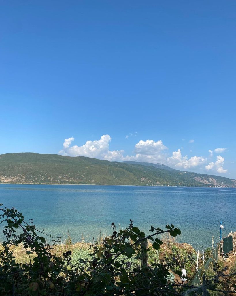
Lini, vendbanimi i hershëm europian buzë liqenit të Ohrit
20 km larg qytetit të Pogradecit, në brigjet perëndimore të Liqenit të Ohrit gjendet fshati turistik Lin. Ky fshat sipas studimeve ka qenë i banuar të paktën që nga epoka e hekurit. Gjetjet arkeologjike në kodrën mbi fshatin në ditët e sotme përfshijnë mure themeli dhe mozaikë të një kishe të hershme bizantine, që daton nga shekulli i 6-të.
Rrënojat e kishës paleokristiane të Linit së bashku me mozaikët e saj në dysheme të shekullit IV-V përfshihen në zonën e mundshme të UNESCO-s të Trashëgimisë Natyrore dhe Kulturore të Rajonit të Liqenit të Ohrit.
Në verën e vitit 2023 gjatë një ekspedite gërmimesh një grup arkeologësh shqiptarë dhe zviceranë, në një bashkëpunim mes Institutit të Arkeologjisë, Akademisë së Studimeve Albanologjike me Universitetin e Bernës, dhe me mbështetjen e laboratorëve të Universitetit të Oxford-it, në Mbretërinë e Bashkuar, zbuluan në fshatin Lin një vendbanim palafit 7800-vjeçar.
Arkeologët zviceranë e shqiptarë mendojnë se Lini mund të jetë vendbanimi më i vjetër në Europë. Gjatë gërmimeve po dalin në dritë elemente drusore, të cilët dëshmojnë për mënyrën e ndërtimit dhe arkitekturës, vegla pune prej stralli, enë të ndryshme qeramike, fragmente kocke kafshësh, dhe janë marrë kampione sedimentologjike për analiza të mëtejshme në laboratorë të specializuar.
Lini prej vitesh është kthyer në një nga destinacionet e vizituara gjerësisht nga turistë vendas e të huaj.
20 km away from the city of Pogradec, on the western shores of Lake Ohrid, lies the tourist village of Lin. According to studies, this village has been inhabited at least since the Iron Age. Archaeological findings on the hill above the village today include foundation walls and mosaics of an early Byzantine church dating back to the 6th century.
The ruins of the Early Christian Church of Lin, along with its floor mosaics from the 4th-5th century, are included in the potential UNESCO World Natural and Cultural Heritage Area of the Lake Ohrid Region.
During the summer of 2023, during an excavation expedition, a group of Albanian and Swiss archaeologists, in a collaboration between the Institute of Archaeology, the Academy of Albanological Studies with the University of Bern, and with the support of the laboratories of the University of Oxford in the United Kingdom, discovered a 7800-year-old pile dwelling settlement in the village of Lin.
Swiss and Albanian archaeologists believe that Lin could be the oldest settlement in Europe. The excavations are bringing to light wooden elements that testify to construction methods and architecture, stone tools, various ceramic vessels, animal bone fragments, and sedimentological samples have been taken for further analysis in specialized laboratories.
For years, Lin has become one of the widely visited destinations by local and foreign tourists.
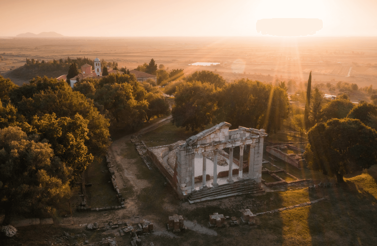
Parku Arkeologjik i Apollonisë – Monumenti magjepsës, ku studioi perandori Oktavian
Qyteti antik i Apollonisë ndodhet në jugperëndim të Shqipërisë, 12 kilometra larg qytetit të Fierit dhe brigjeve të lumit Vjosa apo Aous siç njihet në shkrimet e hershme. Apollonia shtrihet mbi një pllajë kodrinore nga ku zgjerohet fusha pjellore e Myzeqesë deri në detin Adriatik dhe dallohen kodrat e Mallakastrës. Rrënojat e Apollonisë u zbuluan në fillimin e shekullit XIX.
Peizazhi magjepsës i parkut arkeologjik është ruajtur në gjendje jashtëzakonisht të mirë. Aty ndërthuren bukur monumentet e natyrës me horizontin tërheqës, duke ofruar një oaz për të kaluar momente çlodhëse e meditimi.
Si qytet, Apolonia u themelua në fillim të shekullit të shtatë para Krishtit nga kolonizatorët grekë që vinin nga Korinti, dhe shpejt u bë një nga qytetet më të shquara në pellgun e Adriatikut, duke u përmendur më shumë sesa tridhjetë qytetet e tjera, që mbanin të njëjtin emër gjatë antikitetit. Qyteti shtrihej në territorin e bashkësisë politike të Taulantëve dhe njihej gjerësisht si Apollonia e Ilirisë. Të dhënat e para të pranisë së tyre janë dokumentuar rreth vitit 588 para Krishtit.
Emrin qyteti e mori për nder të perëndisë Apolon. Fama e qytetit tërhoqi shumë personalitete të perandorisë më të madhe të botës së lashtë, si filozofi dhe oratori i shquar romak Ciceroni, që e shënoi Apoloninë në veprën e tij, “Philippics” magna urbs et gravis (një qytet i madh dhe i rëndësishëm). Gjatë kësaj periudhe, qyteti u bë një nga portat më të rëndësishme të rrugës transbalkanike Via Egnatia, ndërsa në Akademinë e tij të famshme ka studiuar dhe ka kryer stërvitjen ushtarake perandori romak Oktavian, i shoqëruar nga Agripa, gjeneral dhe burrë shteti i shquar i Perandorisë Romake.
Sipas studimeve llogaritet që qyteti të ketë pasur rreth 60 000 banorë, një shifër rekord për periudhën e Antikitetit. Arkeologët e quajnë Apoloninë Pompei i Shqipërisë, pasi vetëm 10% e territorit të qytetit të dikurshëm është zbuluar deri më sot.
Në Parkun Arkeologjik të Apollonisë shfaqin interes për vizitorët monumenti i Agonotetëve, Odeoni, Biblioteka, muri rrethues, Portiku, vila me impluvium, vila romake me mozaikë, muzeu arkeologjik, Manastirin e vjetër të Shën Mërisë, i cili daton prej shek. XIII dhe Kisha Bizantine e hyjlindëses, e ngritur pranë kopshtit të Manastirit, që daton prej shekullit XIV, etj.
Apollonia është një nga magjitë e turizmit kulturor në Shqipëri. Ajo është lehtësisht e arritshme falë vendndodhjes pranë qyteteve të rëndësishme të Shqipërisë dhe plazheve të bukura të rivierës joniane.
The Archaeological Park of Apollonia – The Enchanting Monument Where Emperor Octavian Studied
The ancient city of Apollonia is located in southwestern Albania, 12 kilometers away from the city of Fier and the shores of the Vjosa River, or Aous as known in early writings. Apollonia is situated on a hilly plateau from where the fertile plain of Myzeqe stretches to the Adriatic Sea, with the hills of Mallakastër visible in the distance. The ruins of Apollonia were discovered in the early 19th century.
The enchanting landscape of the archaeological park has been exceptionally well-preserved. Here, natural monuments intertwine with an attractive horizon, offering an oasis for relaxation and contemplation.
As a city, Apollonia was founded at the beginning of the 7th century BC by Greek colonizers from Corinth and quickly became one of the most prominent cities in the Adriatic basin, mentioned more often than the other thirty cities of the same name in antiquity. The city extended over the territory of the political community of the Taulantii and was widely known as Apollonia of Illyria. The earliest evidence of their presence dates back to around 588 BC.
The city was named in honor of the god Apollo. Apollonia’s fame attracted many notable personalities from the greatest empire of the ancient world, including the renowned Roman philosopher and orator Cicero, who marked Apollonia in his work, “Philippics” as magna urbs et gravis (a great and important city). During this period, the city became one of the most important ports on the trans-Balkan route, Via Egnatia. The city’s famous Academy was where the Roman emperor Octavian, accompanied by Agrippa, a distinguished general and statesman of the Roman Empire, studied and underwent military training.
Studies estimate that the city had about 60,000 inhabitants, a record number for the period of Antiquity. Archaeologists call Apollonia the Pompeii of Albania, as only 10% of the former city’s territory has been uncovered to date.
Visitors to the Archaeological Park of Apollonia find interest in the Monument of Agonothetes, the Odeon, the Library, the surrounding wall, the Portico, the villa with impluvium, the Roman villa with mosaics, the archaeological museum, the old Monastery of Saint Mary, dating back to the 13th century, and the Byzantine Church of the Mother of God, built near the monastery’s garden, dating from the 14th century, among others.
Apollonia is one of the wonders of cultural tourism in Albania. It is easily accessible due to its location near major Albanian cities and the beautiful beaches of the Ionian Riviera.
Antigonea, kryeqendra e qytetërimit antik mbi Luginën e Drinos
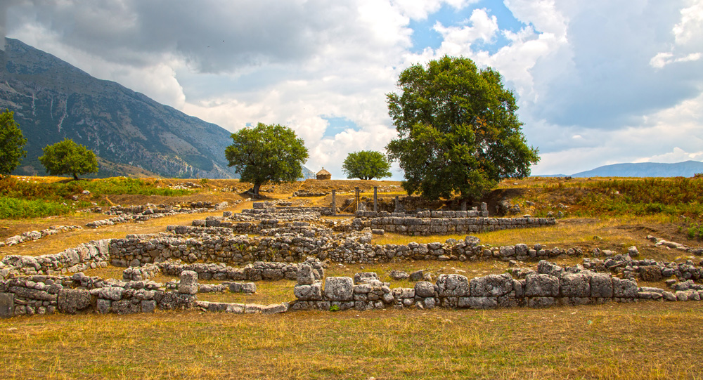
Pranë fshatit Saraqinisht në krahinën e Lunxhërisë, në lindje të qytetit të Gjirokastrës, gjendet Parku arkeologjik i Antigoneas, një nga qytetet antike më të mëdha në territorin e Shqipërisë. Ai është vendbanimi antik më i rëndësishëm në Luginën e Drinos.
Antigonea ndodhet në një pikë dominuese në kodrën e Jermës, 14 km larg qytetit të Gjirokastrës.
Ky qytet antik u themelua nga mbreti Pirro i Epirit në vitin 295 p.e.s., i cili i vuri qytetit emrin e gruas së tij të parë, Antigone. Në fund të shekullit III dhe fillim të shekullit II p.e.s., ky qytet u shndërrua në një qendër të rëndësishme ekonomike, kulturore dhe politike dhe mori formën e një shteti (polis). Antigonea rrethohej me mure 4000 metra të gjata. Në parkun arkeologjik Antigone ka shumë atraksione për t’u vizituar si: mozaiku, kolonat, shëtitorja, një peshore antike, muret rrethuese etj.
Sipas arkeologëve dhe ekspertëve të lashtësisë, lugina e Drinos në rrethin e Gjirokastrës ka një numër jashtëzakonisht të lartë të objekteve arkeologjike dhe vendbanimeve antike. Deri më tani, janë identifikuar rreth 20 vende, duke përfshirë qytete dhe fortifikime antike, varre monumentale, tempuj antikë dhe teatro. Ato shtrihen nga jugu i skajshëm i luginës në kufi me Greqinë, deri në Lekël në pjesën veriore të luginës. Antigonea është qendra kryesore e qytetërimit antik të zonës.
Near the village of Saraqinisht in the Lunxhëri region, east of the city of Gjirokastër, lies the Archaeological Park of Antigonea, one of the largest ancient cities in Albania. It is the most important ancient settlement in the Drino Valley.
Antigonea is situated at a dominant point on the hill of Jermë, 14 km away from the city of Gjirokastër.
This ancient city was founded by King Pyrrhus of Epirus in 295 BCE, who named the city after his first wife, Antigone. By the end of the 3rd century and the beginning of the 2nd century BCE, the city had become a significant economic, cultural, and political center and took the form of a state (polis). Antigonea was surrounded by walls that were 4000 meters long. In the Archaeological Park of Antigonea, there are many attractions to visit, such as the mosaic, columns, promenade, an ancient scale, surrounding walls, etc.
According to archaeologists and experts in antiquity, the Drino Valley in the district of Gjirokastër has an exceptionally high number of archaeological sites and ancient settlements. To date, around 20 sites have been identified, including ancient cities and fortifications, monumental tombs, ancient temples, and theaters. These sites extend from the southernmost part of the valley on the border with Greece to Lekël in the northern part of the valley. Antigonea is the main center of ancient civilization in the area.